ArcGIS API For Js 加载天地图(二)
已被阅读 3011 次 | 文章分类:ArcGIS API For Javascript | 2018-07-16 10:17
上一篇介绍了利用WebTiledLayer的方式加载天地图,这一节使用同时加载底图和标注层的方式加载天地图
一:加载原理
第一个文件TDLayer.js ,是用来加载天地图的底图的,该文件是矢量地图
efine(["dojo/_base/declare",
    "esri/layers/tiled"],
    function (declare) {
    return declare(esri.layers.TiledMapServiceLayer, {
        constructor: function () {
            this.spatialReference = new esri.SpatialReference({ wkid: 4326 });
            this.initialExtent = (this.fullExtent = new esri.geometry.Extent(-180.0, -90.0, 180.0, 90.0, this.spatialReference));
            this.tileInfo = new esri.layers.TileInfo({
                "rows": 256,
                "cols": 256,
                "compressionQuality": 0,
                "origin": {
                    "x": -180,
                    "y": 90
                },
                "spatialReference": {
                    "wkid": 4326
                },
                "lods": [
                    { "level": 2, "resolution": 0.3515625, "scale": 147748796.52937502 },
                    { "level": 3, "resolution": 0.17578125, "scale": 73874398.264687508 },
                    { "level": 4, "resolution": 0.087890625, "scale": 36937199.132343754 },
                    { "level": 5, "resolution": 0.0439453125, "scale": 18468599.566171877 },
                    { "level": 6, "resolution": 0.02197265625, "scale": 9234299.7830859385 },
                    { "level": 7, "resolution": 0.010986328125, "scale": 4617149.8915429693 },
                    { "level": 8, "resolution": 0.0054931640625, "scale": 2308574.9457714846 },
                    { "level": 9, "resolution": 0.00274658203125, "scale": 1154287.4728857423 },
                    { "level": 10, "resolution": 0.001373291015625, "scale": 577143.73644287116 },
                    { "level": 11, "resolution": 0.0006866455078125, "scale": 288571.86822143558 },
                    { "level": 12, "resolution": 0.00034332275390625, "scale": 144285.93411071779 },
                    { "level": 13, "resolution": 0.000171661376953125, "scale": 72142.967055358895 },
                    { "level": 14, "resolution": 8.58306884765625e-005, "scale": 36071.483527679447 },
                    { "level": 15, "resolution": 4.291534423828125e-005, "scale": 18035.741763839724 },
                    { "level": 16, "resolution": 2.1457672119140625e-005, "scale": 9017.8708819198619 },
                    { "level": 17, "resolution": 1.0728836059570313e-005, "scale": 4508.9354409599309 },
                    { "level": 18, "resolution": 5.3644180297851563e-006, "scale": 2254.4677204799655 }
                ]
            });
            this.loaded = true;
            this.onLoad(this);
        },
        getTileUrl: function (level, row, col) {
            return "http://t" + col % 8 + ".tianditu.cn/vec_c/wmts?SERVICE=WMTS&REQUEST=GetTile&VERSION=1.0.0&LAYER=vec&STYLE=default&TILEMATRIXSET=c&TILEMATRIX=" + level + "&TILEROW=" + row + "&TILECOL=" + col + "&FORMAT=tiles";
        }
    });
});
第二个文件是TDAnnoLayer.cs 只需要把第一个文件中的 getTileUrl方法修改下就可以了,比例尺什么的都是一样的,这个是注释图层
define(["dojo/_base/declare",
        "esri/layers/tiled"],
        function (declare) {
        return declare(esri.layers.TiledMapServiceLayer, {
            constructor: function () {
                this.spatialReference = new esri.SpatialReference({ wkid: 4326 });
                this.initialExtent = (this.fullExtent = new esri.geometry.Extent(-180.0, -90.0, 180.0, 90.0, this.spatialReference));
                this.tileInfo = new esri.layers.TileInfo({
                    "rows": 256,
                    "cols": 256,
                    "compressionQuality": 0,
                    "origin": {
                        "x": -180,
                        "y": 90
                    },
                    "spatialReference": {
                        "wkid": 4326
                    },
                    "lods": [
                        { "level": 2, "resolution": 0.3515625, "scale": 147748796.52937502 },
                        { "level": 3, "resolution": 0.17578125, "scale": 73874398.264687508 },
                        { "level": 4, "resolution": 0.087890625, "scale": 36937199.132343754 },
                        { "level": 5, "resolution": 0.0439453125, "scale": 18468599.566171877 },
                        { "level": 6, "resolution": 0.02197265625, "scale": 9234299.7830859385 },
                        { "level": 7, "resolution": 0.010986328125, "scale": 4617149.8915429693 },
                        { "level": 8, "resolution": 0.0054931640625, "scale": 2308574.9457714846 },
                        { "level": 9, "resolution": 0.00274658203125, "scale": 1154287.4728857423 },
                        { "level": 10, "resolution": 0.001373291015625, "scale": 577143.73644287116 },
                        { "level": 11, "resolution": 0.0006866455078125, "scale": 288571.86822143558 },
                        { "level": 12, "resolution": 0.00034332275390625, "scale": 144285.93411071779 },
                        { "level": 13, "resolution": 0.000171661376953125, "scale": 72142.967055358895 },
                        { "level": 14, "resolution": 8.58306884765625e-005, "scale": 36071.483527679447 },
                        { "level": 15, "resolution": 4.291534423828125e-005, "scale": 18035.741763839724 },
                        { "level": 16, "resolution": 2.1457672119140625e-005, "scale": 9017.8708819198619 },
                        { "level": 17, "resolution": 1.0728836059570313e-005, "scale": 4508.9354409599309 },
                        { "level": 18, "resolution": 5.3644180297851563e-006, "scale": 2254.4677204799655 }
                    ]
                });
                this.loaded = true;
                this.onLoad(this);
            },
            getTileUrl: function (level, row, col) {
                return "http://t" + row % 8 + ".tianditu.cn/cva_c/wmts?SERVICE=WMTS&REQUEST=GetTile&VERSION=1.0.0&LAYER=cva&STYLE=default&TILEMATRIXSET=c&TILEMATRIX=" + level + "&TILEROW=" + row + "&TILECOL=" + col + "&FORMAT=tiles";
            }
        });
    });
将上面两个文件放到js文件夹,然后通过requie的方式引入,调用方式如下
<!DOCTYPE html>
<html>
<head>
    <meta http-equiv="Content-Type" content="text/html; charset=utf-8">
    <meta http-equiv="pragma" content="no-cache">
    <meta http-equiv="cache-control" content="no-cache">
    <meta http-equiv="expires" content="0">
    <meta name="viewport" content="initial-scale=1, maximum-scale=1,user-scalable=no" />
    <title></title>
    <link rel="stylesheet" href="http://localhost:8008/3.23/esri/css/esri.css">

	<script type="text/javascript">
            var dojoConfig = {
                async: true, //是否异步
                parseOnLoad: true,
                packages: [{ //解释:require(["js/.."],function(){}) 中  js/ 即为 location的值
                    name: "js", //对应require引用包里的js
                    location: location.pathname.replace(/\/[^/]*$/, '') + '/js' //对应的路径
                }]
            };
        </script>
    <script src="http://localhost:8008/3.23/init.js"></script>

     <script>
      require(["esri/map", "js/TDTLayer","js/TDTAnnoLayer"], function (Map, TDTLayer,TDTAnnoLayer) {
                map = new Map("map", {
                    center: [118.15, 24.55],
                    zoom: 11,
                    logo : false //logo
                });
                var baselayer = new TDTLayer();
                map.addLayer(baselayer);
				var Annolayer = new TDTAnnoLayer();
                map.addLayer(Annolayer);
           });

    </script>
</head>
<body>
   <div id="map"></div>
</body>
</html>
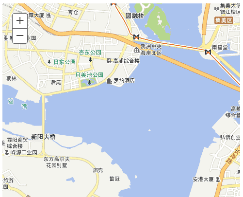
二:效果如下