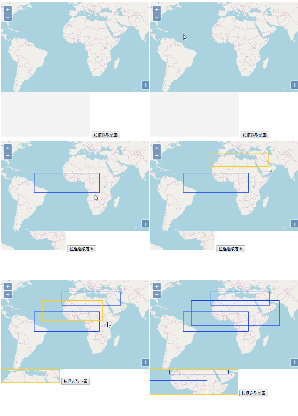
地图打印,拉框截取范围导出截图;openlayers为例
已被阅读 5455 次 | 文章分类:Openlayers | 2019-11-20 21:46
在地图可视化的开发应用程序中,常需要将地图目前叠加的信息包括底图数据,截图保存,保留查看,此时需要使用框选截图的功能
一:基本思路
openlayers地图本来就是一个canvas元素,所以我们可以拿到地图中的每一个像素值,并把它应用到任何地方;其基本的思路:
1、首先调用draw工具交互绘制一个矩形,此处使用linestring的方式绘制,实时显示一个矩形,最后获取矩形四角坐标
draw = new ol.interaction.Draw({
    source: source,
    type: "LineString",
    style: new ol.style.Style({
        stroke: new ol.style.Stroke({
            color: "#ffcc33",
            width: 2
        }),
    }),
    maxPoints: 2,
    geometryFunction: function (coordinates, geometry) {
        console.log(coordinates);
        if (!geometry) {
            geometry = new ol.geom.Polygon(null);
        }
        var start = coordinates[0];
        var end = coordinates[1];
        geometry.setCoordinates([
            [start, [start[0], end[1]], end, [end[0], start[1]], start]
        ]);
        return geometry;
    }
});
2、canvas是原点在左上角的笛卡尔坐标系,所以先将四角坐标转为屏幕像素坐标,得到矩形左上角像素坐标和宽高
let leftBottomPixel=map.getPixelFromCoordinate(leftBottom);
let rightTopPixel=map.getPixelFromCoordinate(rightTop);
var ctx=canvas.getContext('2d');
var origin=[leftBottomPixel[0],rightTopPixel[1]],
    originWidth=rightTopPixel[0]-leftBottomPixel[0],
    originHeight=leftBottomPixel[1]-rightTopPixel[1];
3、最后根据getImageData可获取范围内像素值,使用putImageData将像素赋值到另一个canvas,然后可根据需求保存
二:全部代码
全部代码
var map = new ol.Map({
    layers: [
        new ol.layer.Tile({
            source: new ol.source.OSM()
        })
    ],
    target: "map",
    view: new ol.View({
        center: [0, 0],
        zoom: 2,
        projection:'EPSG:4326'
    })
});
// 选择框图层
var source = new ol.source.Vector({
    wrapX: false
});
//实例化矢量数据图层
var vector = new ol.layer.Vector({
    //数据源
    source: source,
    //样式
    style: new ol.style.Style({
        //笔触
        stroke: new ol.style.Stroke({
            //笔触颜色
            color: "#264df6",
            //笔触宽度
            width: 2
        }),
        //图形样式,主要适用于点样式
        image: new ol.style.Circle({
            //半径大小
            radius: 7,
            //填充
            fill: new ol.style.Fill({
                //填充颜色
                color: "green"
            })
        })
    })
});
//将矢量图层加载到map中
map.addLayer(vector);
var canvas,newCanvas;
map.once('postcompose', function (event) {
    canvas= event.context.canvas;
});
map.renderSync();
var draw,bounds = [];
var extent = [];

document.getElementById("recetange").onclick = function () {
    if (draw) {
        source.clear();
        map.removeInteraction(draw);
    }
    addInteraction();
};
function addInteraction() {
    draw = new ol.interaction.Draw({
        source: source,
        type: "LineString",
        style: new ol.style.Style({
            stroke: new ol.style.Stroke({
                color: "#ffcc33",
                width: 2
            }),
        }),
        maxPoints: 2,
        geometryFunction: function (coordinates, geometry) {
            console.log(coordinates);
            if (!geometry) {
                geometry = new ol.geom.Polygon(null);
            }
            var start = coordinates[0];
            var end = coordinates[1];
            geometry.setCoordinates([
                [start, [start[0], end[1]], end, [end[0], start[1]], start]
            ]);
            return geometry;
        }
    });
    map.addInteraction(draw);
    draw.on("drawend", function (evt) {
        let feature = evt.feature;
        bounds = feature.getGeometry().getExtent();
        let leftBottom=[bounds[0],bounds[1]];
        let rightTop=[bounds[2],bounds[3]];
        PrintBOX(leftBottom,rightTop)
    });
}
function PrintBOX(leftBottom,rightTop){
    let leftBottomPixel=map.getPixelFromCoordinate(leftBottom);
    let rightTopPixel=map.getPixelFromCoordinate(rightTop);
    var ctx=canvas.getContext('2d');
    var origin=[leftBottomPixel[0],rightTopPixel[1]],
        originWidth=rightTopPixel[0]-leftBottomPixel[0],
        originHeight=leftBottomPixel[1]-rightTopPixel[1];
    var imgData=ctx.getImageData(origin[0],origin[1],originWidth,originHeight);
    var resultCanvas=document.getElementById('resultCanvas');
    resultCanvas.width=originWidth;
    resultCanvas.height=originHeight;
    var resultCtx=resultCanvas.getContext('2d');
    resultCtx.putImageData(imgData,0,0);
}
三:效果演示
